Back المرتفعات التايلندية Arabic Tierras altas de Tailandia Spanish ខ្ពង់រាបថៃ Cambodian തായ് മലനിരകൾ Malayalam Terras altas tailandesas Portuguese
Thai Highlands | |
|---|---|
Natural region | |
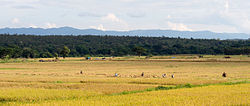
 Rice being harvested in Wang Nuea District, Lampang province. The mountains in the background are part of the Phi Pan Nam Range. | |
 Map of the Thai highlands | |
| Coordinates: 18°30′00″N 98°30′00″E / 18.50000°N 98.50000°E | |
| Country | Thailand |
| Area | Northern Thailand, and parts of Tak and Sukhothai provinces |
| Area | |
| • Total | 107,000 km2 (41,000 sq mi) |
| Population (2009) | |
| • Total | 6,300,000 |
| • Density | 59/km2 (150/sq mi) |
| Time zone | UTC+7 (ICT) |
The Thai highlands or Hills of northern Thailand is a mountainous natural region in the north of Thailand. Its mountain ranges are part of the system of hills extending through Laos, Burma, and China and linking to the Himalayas, of which they may be considered foothills.
The highlands in the north of Thailand are characterized by a pattern of generally steep hill ranges, intermontane basins and alluvial gorges. Elevations are generally moderate, little above 2,000 metres (6,600 ft) for the highest summits. There is a wide range of elevations though, with floors ranging between 200 and 500 metres (660 and 1,640 ft) above sea level. Towards the Lao border, the divide to the Mekong basin becomes higher with peaks occasionally rising above 1,500 metres (4,900 ft) and streams flowing in narrow steep valleys.[1]
The climate is typical of tropical mountains with clearly delineated wet and dry seasons. Winter temperatures can be cool with frosts occurring most years at higher elevations, but no snow even on the highest peaks.
The region of the Thai Highlands encompasses the nine administrative provinces of northern Thailand, based on the six-region system, as well as parts of Tak and Sukhothai Provinces.
Some areas of the highlands are sparsely populated.
- ^ Heritage Thailand, Geography 4 Archived 2011-10-07 at the Wayback Machine