Back منطقة فاراناسي Arabic فاراناسى ARZ वाराणसी जिला Bihari বারাণসী জেলা Bengali/Bangla Districte de Benarés Catalan Vārānasi (distrito sa Indiya) CEB Varanasi (distrikt) Danish Varanasi (Distrikt) German Distrito de Varanasi Spanish Varanasi barrutia Basque
Varanasi | |
|---|---|
| Varanasi | |
Clockwise from top-left: Kashi Vishwanath Temple, Dhamek Stupa at Sarnath, Dept of Electrical Engineering at IIT-BHU, Ahilyabai Ghat, Ramnagar Fort | |
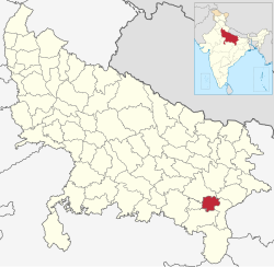
 Location of Varanasi district in Uttar Pradesh | |
| Coordinates (Varanasi): 25°20′N 83°00′E / 25.333°N 83.000°E | |
| Country | |
| State | Uttar Pradesh |
| Division | Varanasi |
| Headquarters | Varanasi |
| Government | |
| • District Magistrate | S. Rajalingam, IAS |
| • Police Commissioner | Mohit Agarwal, IPS |
| • Mayor | Ashok Tiwari, BJP |
| • Lok Sabha constituencies | Varanasi |
| • Member of Parliament, Lok Sabha | Narendra Modi (Prime Minister of India) |
| Area | |
| • Total | 1,535 km2 (593 sq mi) |
| Population (2011) | |
| • Total | 3,676,841[1] |
| • Estimate (2021) | 4,110,000 |
| • Urban | 1,597,051 (43.4%)[2] |
| • Rural | 2,079,790 (56.6%)[2] |
| Demographics | |
| • Literacy | 78.41% |
| • Sex ratio | 913 |
| Language | |
| • Official | Hindi |
| • Additional Official | Urdu |
| • Regional | Bhojpuri |
| Time zone | UTC+05:30 (IST) |
| Vehicle registration | UP-65 |
| Website | Official Website |
Varanasi district is a district in the Indian state of Uttar Pradesh, with the holy city of Varanasi as the district headquarters. It is also the headquarters of the Varanasi division which contains 4 districts (including Varanasi).
It is surrounded by Mirzapur district, Jaunpur district, Ghazipur district, Chandauli district, and Bhadohi district. The Ganga (Ganges) river flows through the district. Part of the Varanasi division, the district occupies an area of 1,535 square kilometres (593 sq mi) and as of the 2011[update] Census of India, it had a population of 3,676,841.
- ^ Cite error: The named reference
districtcensuswas invoked but never defined (see the help page). - ^ a b "Demography"./


