Back বিন্ধ্যপ্রদেশ Bengali/Bangla Vindhya Pradesh German Vindhya Pradesh Spanish विंध्य क्षेत्र Hindi Vindhya Pradesh Italian ವಿಂಧ್ಯ ಪ್ರದೇಶ Kannada Виндхья-Прадеш Russian விந்தியப் பிரதேசம் Tamil Vindhya Pradesh Uzbek 溫迪亞邦 Chinese
| Vindhya Pradesh | |||||||||
|---|---|---|---|---|---|---|---|---|---|
| State of India | |||||||||
| 1948–1956 | |||||||||
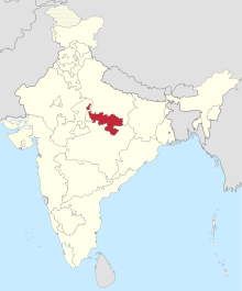
 1951 map of India. Vindhya Pradesh is shown in the centre. | |||||||||
| Capital | Rewa | ||||||||
| Area | |||||||||
• | 61,131.5 km2 (23,603.0 sq mi) | ||||||||
| Population | |||||||||
• | 3,600,000 | ||||||||
| History | |||||||||
• Creation of Vindhya Pradesh State | 1948 | ||||||||
| 1956 | |||||||||
| |||||||||
| Pranab Kumar Bhattacharyya (1977). Historical Geography of Madhya Pradesh from Early Records. Delhi: Motilal Banarsidass. pp. 54–5. | |||||||||
Vindhya Pradesh was a former state of India. It occupied an area of 61,131.5 km2 (23,603 sq. miles).[1] It was created in 1948 as Union of Baghelkhand and Bundelkhand States, shortly after Indian independence, from the territories of the princely states in the eastern portion of the former Central India Agency. It was named as Vindhya Pradesh on 25 January 1950 after the Vindhya Range, which runs through the centre of the province. The capital of the state was the former princely state of Rewa. It lays between Uttar Pradesh to the north and Madhya Pradesh to the south, and the enclave of Datia, which lay a short distance to the west, was surrounded by the state of Madhya Bharat.
Vindhya Pradesh was merged into Madhya Pradesh in 1956, following the States Reorganisation Act.[2]
- ^ Bhattacharyya, P. K. (1977). Historical Geography of Madhya Pradesh from Early Records. Delhi: Motilal Banarsidass. pp. 54–5. ISBN 0-8426-909-13.
- ^ "States Reorganisation Act, 1956". India Code Updated Acts. Ministry of Law and Justice, Government of India. 31 August 1956. pp. section 9. Retrieved 16 May 2013.