Back Prefektur Okinawa ACE Okinawa-prefektuur Afrikaans أوكيناوا (محافظة) Arabic اوكيناوا ARZ অকিনাৱা প্ৰশাসনিক অঞ্চল Assamese Okinava prefekturası Azerbaijani اوکیناوا اوستانی AZB Préféktur Okinawa BAN Okinavas prefektūra BAT-SMG Prepektura kan Okinawa BCL
Okinawa Prefecture
沖縄県 | |
|---|---|
| Japanese transcription(s) | |
| • Japanese | 沖縄県 |
| • Rōmaji | Okinawa-ken |
 Tourists on traditional buffalo carts arrive at Yubu Island in Taketomi Town, Yaeyama District, Okinawa Prefecture. | |
| Anthem: 沖縄県民の歌 (Okinawa kenmin no uta) | |
 | |
| Coordinates: 26°30′N 128°0′E / 26.500°N 128.000°E | |
| Country | |
| Region | Kyushu |
| Island | Okinawa, Daitō, Miyako, Yaeyama, and Senkaku |
| Capital | Naha |
| Subdivisions | Districts: 5, Municipalities: 41 |
| Government | |
| • Governor | Denny Tamaki |
| Area | |
| • Total | 2,281 km2 (881 sq mi) |
| • Rank | 44th |
| Population (May 1, 2020) | |
| • Total | 1,466,870 |
| • Rank | 29th |
| • Density | 640/km2 (1,700/sq mi) |
| GDP | |
| • Total | JP¥ 4,633 billion US$ 42.5 billion (2019) |
| ISO 3166 code | JP-47 |
| Website | www |
| Symbols of Japan | |
| Bird | Okinawa woodpecker (Sapheopipo noguchii) |
| Fish | Banana fish (Pterocaesio diagramma, "takasago", "gurukun") |
| Flower | Deego (Erythrina variegata) |
| Tree | Pinus luchuensis ("ryūkyūmatsu") |
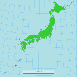
Okinawa Prefecture (Japanese: 沖縄県, Hepburn: Okinawa-ken) is the southernmost and westernmost prefecture of Japan.[2] It has a population of 1,457,162 (as of 2 February 2020[update]) and a geographic area of 2,281 km2 (880 sq mi).
Naha is the capital and largest city, with other major cities including Okinawa, Uruma, and Urasoe.[3] Okinawa Prefecture encompasses two thirds of the Ryukyu Islands, including the Okinawa, Daitō and Sakishima groups, extending 1,000 kilometres (620 mi) southwest from the Satsunan Islands of Kagoshima Prefecture to Taiwan (Hualien and Yilan Counties). Okinawa Prefecture's largest island, Okinawa Island, is the home to a majority of Okinawa's population. Okinawa's indigenous ethnic group is the Ryukyuan people, who also live in the Amami Islands of Kagoshima Prefecture.
Okinawa was ruled by the Ryukyu Kingdom from 1429 and unofficially annexed by Japan after the Invasion of Ryukyu in 1609. Okinawa was officially founded in 1879 by the Empire of Japan after seven years as the Ryukyu Domain, the last domain of the Han system. Okinawa was occupied by the United States during the Allied occupation of Japan after World War II and was governed by the Military Government of the Ryukyu Islands from 1945 to 1950 and Civil Administration of the Ryukyu Islands from 1950 until the prefecture was returned to Japan in 1972. Okinawa comprises just 0.6 percent of Japan's total land mass, but about 26,000 (75%) of United States Forces Japan personnel are assigned to the prefecture; the continued U.S. military presence in Okinawa is controversial.[4][5]

- ^ "2020年度国民経済計算(2015年基準・2008SNA) : 経済社会総合研究所 - 内閣府". 内閣府ホームページ (in Japanese). Retrieved May 18, 2023.
- ^ Nussbaum, Louis-Frédéric. (2005). "Okinawa-shi" in Japan Encyclopedia, p. 746–747, p. 746, at Google Books
- ^ Nussbaum, "Naha" in p. 686, p. 686, at Google Books
- ^ Inoue, Masamichi S. (2017), Okinawa and the U.S. Military: Identity Making in the Age of Globalization, Columbia University Press, ISBN 978-0-231-51114-8, archived from the original on February 17, 2017, retrieved February 12, 2017
- ^ "U.S. civilian arrested in fresh Okinawa DUI case; man injured". The Japan Times. June 26, 2016. Archived from the original on July 31, 2017.
Under a decades-old security alliance, Okinawa hosts about 26,000 U.S. service personnel, more than half the total Washington keeps in all of Japan, in addition to base workers and family members.

