Back Mont Dolent ALS مونت دولينت Arabic جبل مونت دولينت ARZ Мон Долан Bulgarian Mont Dolent Catalan Mont Dolent CEB Mont Dolent Czech Mont Dolent German Mont Dolent Spanish کوه دولنت Persian
| Mont Dolent | |
|---|---|
 Mont Dolent | |
| Highest point | |
| Elevation | 3,823 m (12,543 ft) |
| Prominence | 330 m (1,080 ft)[1] |
| Parent peak | Aiguille Verte |
| Listing | Alpine mountains above 3000 m |
| Coordinates | 45°55′21″N 7°2′46″E / 45.92250°N 7.04611°E |
| Geography | |
| Location | Aosta Valley, Italy Valais, Switzerland Haute-Savoie, France |
| Parent range | Graian Alps |
| Climbing | |
| First ascent | 9 July 1864 by A. Reilly, Edward Whymper, Michel Croz, H. Charlet and M. Payot |
| Easiest route | South face and south-east ridge (PD) |

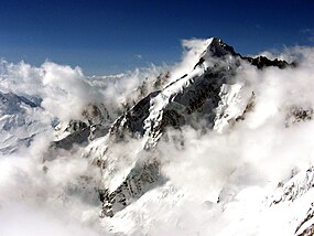
Mont Dolent (3,823 metres (12,543 ft)) is a mountain in the Mont Blanc massif and lies on the border between Italy, Switzerland and France.
As a mountain, Mont Dolent is regarded as the tripoint between Italy, Switzerland and France, although the tripoint itself lies at 3,749 metres, less than 100 metres north-west of its summit.[2][3][4]
In 1954, a statue of the Virgin Mary was erected on Mont Dolent's summit by the young people of Valais.
- ^ Retrieved from the Swisstopo and IGN topographic maps. The key col is Col du Dolent (3,490 m).
- ^ Portale Cartografico Nazionale Archived 2009-09-05 at the Wayback Machine
- ^ "Italy – Switzerland Boundary" (PDF). Florida State University. International Boundary Study. US. Department of State. 23 October 1961. Archived from the original (PDF) on 10 June 2016. Retrieved 22 August 2016.
- ^ Cartes IGN (Map). L'Institut national de l'information géographique et forestière. Retrieved 22 August 2016.
