Back روكسبري Arabic روکسبوری، کانتیکت AZB Роксбъри Bulgarian Roxbury (Connecticut) Catalan Роксбери (Коннектикут) CE Roxbury, Connecticut Welsh Roxbury (Connecticut) Spanish Roxbury (Connecticut) Basque راکسبری، کنتیکت Persian Roxbury (Connecticut) French
Roxbury | |
|---|---|
| Town of Roxbury | |
 Town Hall | |
| Coordinates: 41°33′07″N 73°18′09″W / 41.55194°N 73.30250°W | |
| Country | |
| U.S. state | |
| County | Litchfield |
| Region | Northwest Hills |
| Incorporated | 1796 |
| Government | |
| • Type | Selectman-town meeting |
| • First selectman | Patrick Roy (D) |
| • Selectman | Russell Dirienzo (R) |
| • Selectwoman | Kim Tester (D) |
| Area | |
| • Total | 26.4 sq mi (68.3 km2) |
| • Land | 26.3 sq mi (68.1 km2) |
| • Water | 0.04 sq mi (0.1 km2) |
| Elevation | 541 ft (165 m) |
| Population (2020) | |
| • Total | 2,260 |
| • Density | 86/sq mi (33/km2) |
| Time zone | UTC−5 (Eastern) |
| • Summer (DST) | UTC−4 (Eastern) |
| ZIP code | 06783 |
| Area code(s) | 203/475, 860/959 |
| FIPS code | 09-65930 |
| GNIS feature ID | 0213498 |
| Website | www |
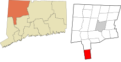
Roxbury is a town in Litchfield County, Connecticut, United States. The population was 2,260 at the 2020 census.[1] The town is located 65 miles (105 km) northeast of New York City, and is part of the Northwest Hills Planning Region.
- ^ "Census - Geography Profile: Roxbury town, Litchfield County, Connecticut". United States Census Bureau. Retrieved December 20, 2021.


