| Karenni States | |||||||||
|---|---|---|---|---|---|---|---|---|---|
| Princely States of British Burma | |||||||||
| 18th century–1959 | |||||||||
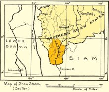
 1917 map of the Karenni States | |||||||||
| Area | |||||||||
• 1901 | 8,106 km2 (3,130 sq mi) | ||||||||
| Population | |||||||||
• 1901 | 45,795 | ||||||||
| • Type | Monarchy | ||||||||
| History | |||||||||
• Independence of the feudatory Karenni predecessor state. | 18th century | ||||||||
• Abdication of the Kayah rulers | 1959 | ||||||||
| |||||||||


| History of Myanmar |
|---|
 |
|
|
|
|
|
|
The Karenni States, also known as Red Karen States, was the name formerly given to the states inhabited mainly by the Red Karen, in the area of present-day Kayah State, eastern Burma. They were located south of the Federated Shan States and east of British Burma.
The British government recognised and guaranteed the independence of the Karenni States in an 1875 treaty with Burmese King Mindon Min, by which both parties recognised the area as belonging neither to Burma nor to Great Britain. Consequently, the Karenni States were never fully incorporated into British Burma. The Karenni states formed for a time the "Kayah State" in post-independent Burma,[1] but on 29 April 1959 both the Shan and the Kayah rulers formally surrendered their ruling powers to the Burmese government.[2]
