Back مقاطعة شا تين Arabic Sha Tin (kapital sa distrito) CEB Sha Tin District German Sha Tin Spanish Sha Tin barrutia Basque منطقه شا تین Persian Sha Tin (district) French Sâ-thièn-khî HAK שא טין HE Száthín Hungarian
Sha Tin
沙田區 Shatin | |
|---|---|
| Sha Tin District | |
 Day view of the Sha Tin District skyline | |
 | |
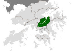
 Location of Sha Tin District within Hong Kong | |
| Coordinates: 22°23′14″N 114°11′43″E / 22.38715°N 114.19534°E | |
| Country | Hong Kong |
| Region | New Territories |
| District Council Constituencies | 41 |
| Government | |
| • District Council Chairman | Mak Yun-Pui,Chris |
| • District Council Vice-Chairman | Sin Cheuk-Nam |
| Area | |
| • Total | 69.27 km2 (26.75 sq mi) |
| • Land | 69.27 km2 (26.75 sq mi) |
| Lands Department[2] | |
| Population (2021) | |
| • Total | 692,806[1] |
| • Density | 10,082/km2 (26,110/sq mi) |
| Census and Statistics Department[1] | |
| Time zone | UTC+8 (Hong Kong Time) |
| Website | districtcouncils.gov.hk |
| Sha Tin District | |||||||||||||||
|---|---|---|---|---|---|---|---|---|---|---|---|---|---|---|---|
| Traditional Chinese | 沙田區 | ||||||||||||||
| Simplified Chinese | 沙田区 | ||||||||||||||
| Jyutping | Saa1 tin4 keoi1 | ||||||||||||||
| Literal meaning | "sand field district" | ||||||||||||||
| |||||||||||||||
Sha Tin District is one of the 18 districts of Hong Kong. As one of the 9 districts located in the New Territories, it covers the areas of Sha Tin, Tai Wai, Ma On Shan, Fo Tan, Siu Lek Yuen, Kwun Yam Shan and Ma Liu Shui. The district is the most populous district in Hong Kong, with a population of 659,794 as per 2016 by-census, having a larger population than many states or dependencies including Iceland, Malta, Montenegro and Brunei.[3]
The Sha Tin District covers approximately 69.4 km2 (26.8 sq. mi),[4] including Sha Tin New Town and several country parks. Built mostly on reclaimed land in Sha Tin Hoi, the well-developed Sha Tin New Town comprises mainly residential areas along the banks of the Shing Mun River Channel. In the early 1970s it was a rural township of about 30,000 people. After Sha Tin's first public housing estate, Lek Yuen Estate, was completed in 1976, the settlement began to expand. Today, about 65% of the district's population live in public rental housing, housing under Hong Kong's Tenants Purchase Scheme, or Home Ownership Scheme.[5]
- ^ a b 2021 Population Census: Summary Results (PDF). Census and Statistics Department, Hong Kong SAR (Report). February 2022.
- ^ "Hong Kong Geographic Data (As at October 2021)". Lands Department, Hong Kong SAR. January 2022. Retrieved 4 August 2022.
- ^ 2016 Population By-census Summary Results (PDF), Hong Kong: Census and Statistics Department, 2017, p. 19, retrieved 9 February 2020
- ^ "District Highlights". Sha Tin District Council. April 2012. Archived from the original on 10 March 2014. Retrieved 11 June 2012.
- ^ Lill, Coran (2 July 2004). "TTP to build Asian towers". ShareChat.co.nz. Retrieved 11 June 2012.