Back Tambunan CEB Distrikt Tambunan German District de Tambunan French Daerah Tambunan Malay தம்புனான் மாவட்டம் Tamil 担布南县 Chinese Tambunan Koān ZH-MIN-NAN
Tambunan District | |
|---|---|
| Daerah Tambunan | |
| Other transcription(s) | |
| • Jawi | داءيره تمبونن |
| • Chinese | 担布南县 (Simplified) 擔布南縣 (Traditional) Dānbùnán xiàn (Hanyu Pinyin) |
| • Tamil | தம்புனான் மாவட்டம் Tampuṉāṉ māvaṭṭam (Transliteration) |
| • Kadazandusun | Watas Tambunan |
 Tambunan District Council office. | |
| Nickname(s): "the place where the Warrior, Gombunan and Tamadon were born." | |
 | |
| Coordinates: 5°40′26.47″N 116°21′53.58″E / 5.6740194°N 116.3648833°E | |
| Country | |
| State | |
| Division | Interior |
| Capital | Tambunan |
| Government | |
| • District Officer | Blasius Sobitun Makajil |
| Area | |
| • Total | 1,347 km2 (520 sq mi) |
| Population (2010) | |
| • Total | 35,667 |
| Website | www www |

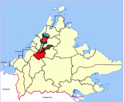
The Tambunan District (Malay: Daerah Tambunan) is an administrative district in the Malaysian state of Sabah, part of the Interior Division which includes the districts of Beaufort, Keningau, Kuala Penyu, Nabawan, Sipitang, Tambunan and Tenom. The capital of the district is in Tambunan Town.
